Geography

From the moment we are born, it is our instinct to begin to explore our world around us with all our senses.
At Houghton, we feel it is important to nurture and encourage that natural curiosity, to shape and direct it to turn the children into inquisitive, questioning learners who look closely at the world around them and begin to be able to interpret what they see. As a whole school, we look at countries around the world and learn about the similarities and differences between British culture and others.
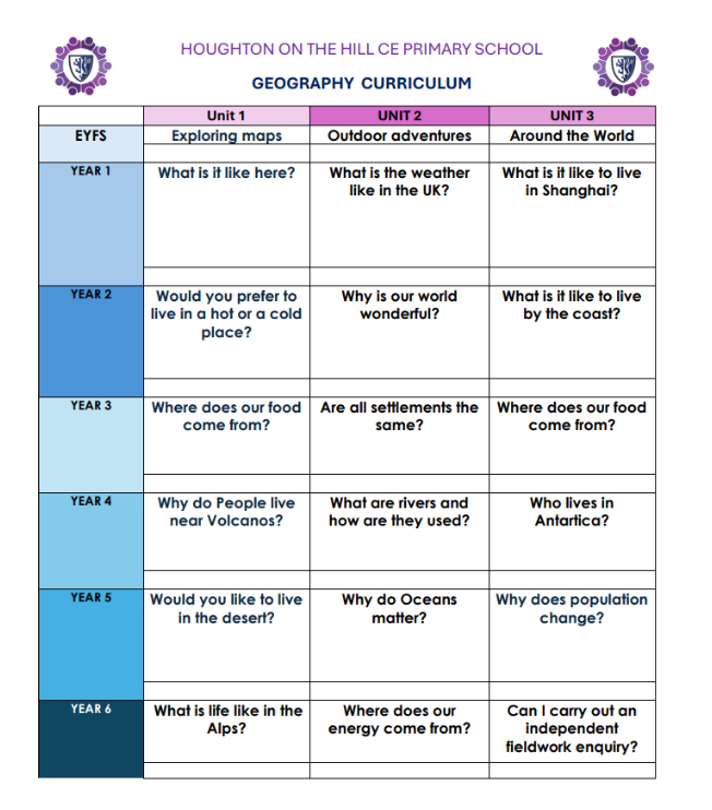
In Reception, Geography comes under the curriculum area of ‘Understanding the World,’ providing links with science and history. We encourage the children to explore our outdoor area and investigate the plants and animals that we find there – we draw them, label them, research them on the internet, make homes for them and follow the children’s interests in learning more about them. We introduce the beginnings of map work, encouraging children to look closely at what they see and to draw it accurately.
In Key stage 1 we begin to look in more detail at our local area, particularly during our topic of ‘Homes’ – we will go out into Houghton to look at different buildings and homes and compare them with those in other areas and countries. We will learn to draw and interpret maps and to develop a variety of other skills through our topic work, including those of enquiry, problem-solving, investigating and presenting our work, calling on skills learned in Maths and English and applying them in new ways.
In Key Stage 2, Geography will be taught through a variety of locational knowledge, place knowledge, human and physical geography and geographical skills and fieldwork. Each year group will focus on three geographical topics during the year. These will often link with their learning in other curriculum areas. Each topic will develop geographical skills and enquiry through active learning. Children will learn the necessary skills to investigate a variety of people, places and environments at different scales and will begin to make links between different people and places in the world. Children will begin to recognise and explain patterns made by individual physical and human features in the environment and explain how these can cause changes. They will also learn to name and locate countries and cities of the UK; the worlds countries especially Europe and North and South America.
Sustainable development is a strand that continues through each year group. By the end of key stage 2, children will have has the opportunity to recognise how people can improve the environment and will discuss how and why people seek to manage environments sustainably. At Houghton we also aim to instil in children a sense of environmental responsibility and encourage them to understand environmental issues at a local and global level. We have an Eco-Committee made up of two children from each class, who are beginning to look at important areas such as our energy efficiency and reducing litter around the school.
Running through all of our Geography work at Houghton is the idea that we are motivating and inspiring our children to find out about their world, both physical and human, so that they can take an active part in contributing to and protecting this world as they grow up.
|
|
||||||||
